
- Smoke from a series of Canadian wildfires has been drawn across the Atlantic Ocean.
- Satellite and modeling data indicated that some of the billowing smoke had reached Ireland.
- Thick smoke has blanketed Atlantic Canada in the country’s heaviest wildfire season on record.
Smoke from Canadian wildfires has been drawn across the Atlantic Ocean as far east as Ireland, an eerie sight in late September during the country’s heaviest wildfire season on record.
Satellite images on Wednesday looked fairly typical for September over the Atlantic Ocean. A pair of storms – one of which the UK Met Office has named Storm Agnes – have been lined up, heading for Ireland and the UK
However, as the image below showed, there were also plumes of smoke coming from Canada across the ocean towards Ireland. Smoke was particularly dense over Nova Scotia, New Brunswick, Newfoundland and even parts of Downeast Maine.
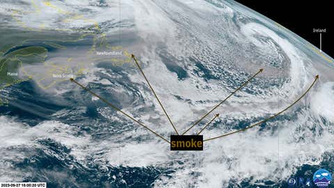
A visible satellite image taken at 12 noon EDT on September 27, 2023, showed plumes of high-altitude wildfire smoke (shown in brown) extending from the Canadian Sea Lines across the Atlantic Ocean, heading for Ireland.
(Original image: NOAA/CIRA/RAMMB (with smoke caption added))
How did the smoke get there? A series of Canadian wildfires that started in late spring continue to burn here in early fall. According to the Canadian Interagency Wildfire CentreThere were nearly 900 active fires burning across the country as of September 27. More than half of these fires were reported to be “out of control.”
In this case, upper-level winds took this smoke from western and central Canada and pushed it into Atlantic Canada. The jet stream then took it from there, sending plumes of billowing smoke across the Atlantic, eventually tangling with a few Atlantic storms before arriving in Ireland. You can see this in a sample diagram below.
It was unlikely that any of this smoke would reach the ground in Ireland or the UK, and would have been difficult to distinguish due to their exposure to the winds of Storm Agnes.

This forecast model chart shows rising smoke (in varying shades of grey) and upper-level winds transporting smoke across the Atlantic Ocean on September 26-27, 2023.
(Model: NASA, ECMWF)
How strange this time of year is: Over the past few months, we have seen periods where more dense wildfire smoke was drawn from Canada into the United States, especially in June.
What’s weird about this is that it happens toward the end of September, when thoughts of wildfire smoke coming out of Canada typically start to give way to more powerful cold fronts with fresh, clean fall air.
This is a function of the severity of wildfires in Canada.
Fires have scorched nearly 69,000 square miles of land in Canada so far this year, an area roughly the size of Missouri and the largest area ever recorded since the early 1980s.
As research scientist Yann Boulanger points out, about a third of Canada’s average entire fire season burned land in just one day last Saturday.
It remains to be seen to what extent we will continue to see wildfire smoke drawn across the Atlantic, or, occasionally, into parts of the United States.
Jonathan Erdmann is a senior meteorologist at Weather.com, and has been an incurable weather geek ever since a tornado missed his childhood home in Wisconsin when he was seven years old. x/twitter, Facebook And the threads.
The Weather Company’s primary journalistic mission is to report on breaking weather news, the environment, and the importance of science in our lives. This story does not necessarily represent the position of our parent company, IBM.

“Infuriatingly humble analyst. Bacon maven. Proud food specialist. Certified reader. Avid writer. Zombie advocate. Incurable problem solver.”